

Google Earth Now Has a Flight Simulator in Your Browser. Here's How to Fly It.
Google Earth has a flight simulator built into the web version now. There is nothing to install and nothing to buy. Open earth.google.com in a desktop browser, click Tools, choose Flight simulator, and you are in the air over whatever spot you were looking at.
We tried it from our office in Oak Ridge North and were flying up Interstate 45 toward Conroe about ten seconds later. This article covers how to launch it, the controls, what to do when it runs badly, and the more serious tools Google added to the same menu last month, which matter a lot more to Houston builders, engineers, and real estate teams than the airplane does.
In this article
- What Is the Google Earth Flight Simulator?
- How Do You Open It?
- What Are the Controls?
- How Do You Read the Display?
- Why Is It Choppy or Not Loading?
- What Are the New Site Analysis Tools?
- Frequently Asked Questions
What Is the Google Earth Flight Simulator?
It is a simple airplane you can fly over Google Earth’s 3D imagery of the real world. Google added it to Google Earth on the web in June 2026 and labels it Experimental.
The idea is not new. A flight simulator has been tucked inside the installed desktop program, Google Earth Pro, since 2007, where it started life as a hidden keyboard shortcut. What changed is that you no longer need the desktop install. It runs in a browser tab.
Google is clear about what it is for. In its own documentation, the company says the simulator “is designed for casual exploration rather than high-fidelity aerodynamic training.” Nobody is logging flight hours on this. It is a fast, fun way to see a place from the air.
How Do You Open It?
- On a computer, go to earth.google.com and click Explore Earth.
- Search for a starting point, such as your office or your neighborhood.
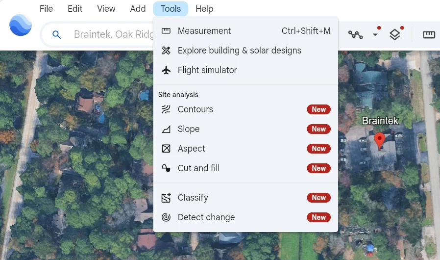
- Open the Tools menu in the top menu bar.
- Click Flight simulator.
One tip before you take off. If the ground looks like a plain road map, switch the basemap from Map to Satellite. The satellite view is what gives you real rooftops, trees, and highways.
To leave, click the back arrow in the upper left corner.
What Are the Controls?
These are the controls Google documents for the web version.
| Action | Control |
|---|---|
| More thrust | Page Up, or the on-screen throttle bar |
| Less thrust | Page Down, or the on-screen throttle bar |
| Climb or dive | Up and Down arrows |
| Bank left or right | Left and Right arrows |
| Fly with the mouse | Click inside the simulator to toggle mouse control |
| Exit | Back arrow, upper left |
Small taps work better than holding a key down. If you do fly into the ground, the simulator stops and offers a You crashed! Restart button that puts you back at a safe altitude.
Many laptop keyboards have no dedicated Page Up and Page Down keys. On most of them, hold Fn and press the Up or Down arrow, or just drag the throttle bar on screen.
A lot of older guides list extra keys for flaps, landing gear, and brakes, plus a choice between an F-16 and a propeller plane. Those belong to the desktop Google Earth Pro simulator. Google’s documentation for the web version lists only the controls above.
How Do You Read the Display?
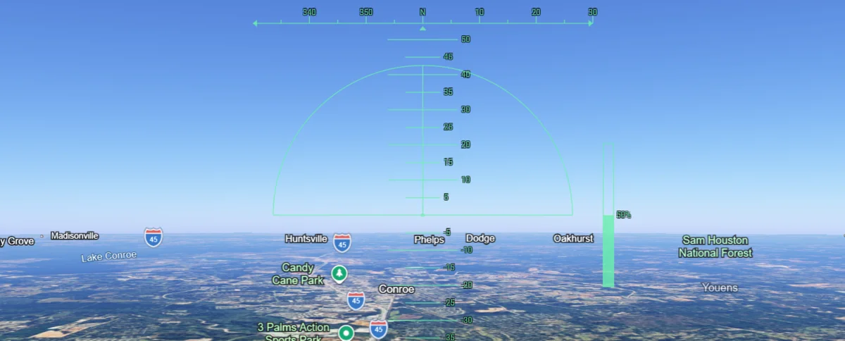
The green overlay is a heads-up display, modeled on what a pilot sees projected on the windscreen.
- The strip across the top is your compass heading.
Nis north,90is east,180is south,270is west. - The numbered ladder in the middle is pitch, in degrees. Numbers above the horizon mean the nose is pointed up.
- The vertical bar on the right is the throttle, shown as a percentage.
In our screenshot at the top of this article, we are heading due north at 50 percent throttle with Conroe just ahead, Lake Conroe off to the left, and Huntsville on the horizon.
Screenshots: Google Earth.
Why Is It Choppy or Not Loading?
The simulator streams 3D buildings and imagery as you fly, and it leans on your graphics hardware to draw them. When it stutters, the cause is usually one of these.
- You are on a phone or tablet. The simulator only works in Google Earth on the web, on a computer. It is not in the mobile app.
- Hardware acceleration is off. In Chrome or Edge, open Settings, go to System, and turn on the graphics acceleration option, then restart the browser.
- The connection is slow. Scenery arrives late and looks blurry until it catches up. Slow down or climb higher.
- The PC is old. Machines with aging integrated graphics struggle with any 3D map, not just this one.
- Your usual shortcuts stopped working. That one is intentional. Google turns off the normal map shortcuts during flight so they do not fight with the flight keys.
If a computer that should handle this cannot, it is often the same underlying issue that makes video calls and large spreadsheets drag. That is worth a ticket to your IT help desk rather than something to live with.
What Are the New Site Analysis Tools?
Look again at that Tools menu. Right under the flight simulator is a Site analysis section, and most of it is tagged New. Google announced these tools on September 22, 2026, and for a lot of businesses they are the real story.
| Tool | What it does |
|---|---|
| Contours | Draws elevation lines across a site, at intervals as tight as 1 meter |
| Slope | Color codes how steep the ground is, which helps flag unbuildable areas and runoff paths |
| Aspect | Shows which direction each slope faces, useful for sun exposure and drainage |
| Cut and fill | Estimates how much soil must be moved to reach a target elevation |
| Detect change | Uses AI to compare two years of satellite data and heat-map where the land changed |
The menu also lists a Classify tool. Google’s announcement did not cover it, so we will leave it out until we have tested it ourselves.
Think about what that means in the Houston area, where a few feet of elevation decides whether a property floods. A developer, civil engineer, or commercial broker can pull contours and slope on a tract in Montgomery County before anyone drives out to it. Detect change can show how much the land around a site has been cleared or built on over the past several years.
Two cautions. Google says these tools are a first look and do not replace a survey on the ground. And the Standard plan limits the terrain tools to one generated layer per month, with more available on the paid professional plans.
Tools like these are showing up inside software your team already has open, often with no announcement. Knowing what is there, and which of it is safe and useful for your business, is part of what good IT support in Houston should be doing for you.
Frequently Asked Questions
Is the Google Earth flight simulator free?
Yes. The flight simulator is part of Google Earth on the web and there is no charge to open it and fly. Google labels it Experimental, which means it can change or be removed.
How do I start the flight simulator in Google Earth?
On a computer, open earth.google.com, click Explore Earth, open the Tools menu in the top menu bar, and select Flight simulator. In the older desktop program, Google Earth Pro, the shortcut is Ctrl+Alt+A on Windows.
What are the Google Earth flight simulator controls?
Page Up and Page Down raise and lower thrust. The Up and Down arrow keys climb and dive, and the Left and Right arrow keys bank. Clicking inside the simulator toggles mouse control. The back arrow in the upper left exits.
Does the Google Earth flight simulator work on a phone or iPad?
No. Google states that the flight simulator is only available in Google Earth on the web and is not supported on mobile devices or in the Google Earth mobile app.
Can I use it to learn to fly?
No. Google describes it as built for casual exploration, not realistic flight training. The physics are simplified on purpose.
Wondering what else your team’s software can already do?
Most businesses use a small fraction of the tools they are already paying for. In a free consultation, Braintek will look at how your team works and point out what you are missing, what is slowing you down, and what should be locked down.